Although Erin continues its path without touching land, the east coast of the United States is now on alert for dangerous waves and storm surges of up to 1.2 meters that can be potentially fatal.
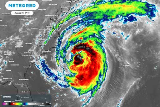
Washington.- Erin's outer bands grazed the Outer Banks, a thin chain of islands along the Atlantic coast of North Carolina on Wednesday night, according to the Miami-based National Hurricane Center (NHC).
The hurricane, category 2 on the Saffir-Simpson scale, as it approached North Carolina, caused flooding in the streets near the beach, according to images broadcast on television.
“When there are floods, there is a great risk of death, and what we do not want people to die,” said the governor of the state, Josh Stein, who, in preparation for the hydrometeorological event, declared a state of emergency.
Forecasts located the center of the storm about 345 km south-southeast of Cape Hatteras, North Carolina, and 780 km west of Bermuda.
The hurricane center also indicated that Erin is likely to begin weakening tonight or tomorrow, but will remain as a hurricane over the weekend.
The Atlantic hurricane season, which began on June 1 and ends on November 30, is at its peak. The CNH has already increased by 70 percent the probability that the area of thunderstorms following Erin will become the next storm of the season in the coming seven days. (PL)